
|
|
Saturday June 29th was a date which had been on my mind for almost a week. The models were in strong agreement for thunderstorms across Ireland and N. Ireland marking a break down after a week of high pressure and warm temperatures. A hot plume of unstable air had advected N from S. Africa bringing with it an EML of air with exceptionally high CAPE values, in fact, among some of the highest instability values ever seen in this part of the world and similar to what one would see on a good set-up over the great plains of the USA. On June 27th a major storm event passed close to Ireland, a giant Mesoscale Convective System (MCS) formed off the W coast and began moving NW, the storm was massive with an enormous anvil half the size of Ireland visible on satellite imagery with cloud top temperatures of -60C aloft. Unfortunately for storm fans this epic storm was too far off shore and moved further out to sea with time.
This MCS was producing prolific lightning rates but it was a tough blow for storm chasers, the storm couldn't be seen from anywhere and thus was a wasted opportunity. Had this MCS passed over land it would most certainly have made headlines, there would have been serious damage to life and property from lightning, flooding and straight line winds. If it had even passed within 50 miles from the west coast at night fall it would have produced the best night time lightning event for years, however it may as well have been a none event and to make matters worse the storm was so organized it passed to the NW of Scotland and kept moving N over the colder North Sea still producing lightning for hours on end, what a show it would have been and witnessed only by ships at sea, this let-down was just another one in a growing list of storm busts this season across Ireland.
The next event was Saturday June 29th when the plume from S. Africa was due to spark off storms across the E of N. Ireland during the early hours. These storms would be elevated but with major lightning potential however my attention was focused on the W for the evening time which I will get to in a moment. The problem with elevated storms is that in my opinion they are quite frankly rubbish for photography if they impact during daylight hours. These storms have exceptional high bases, are usually grey-like pea soup and have no decent structure at all, so unless you are lucky to catch a c-g on camera then they really are of little interest to storm photographers. I have learned my lessons from chasing these in the past, however if they do appear during twilight or night time then this would take things to the next level potentially producing the lightning display of a life time.
On Saturday morning I was suddenly awoken at 08.00 by distant rumbling of thunder, I can't imagine a better wake up call in the morning!, I checked radar and sferics and was shocked to see a very active plume which was more widespread and further inland than many had anticipated. I quickly changed and ran out the door into the van, I saw an elevated gust front approach Maghera and could hear distant rumbles getting closer, I couldn't believe I was in the action so early in the morning, this only happened to me once before in 2008 during surprise morning thunderstorms.
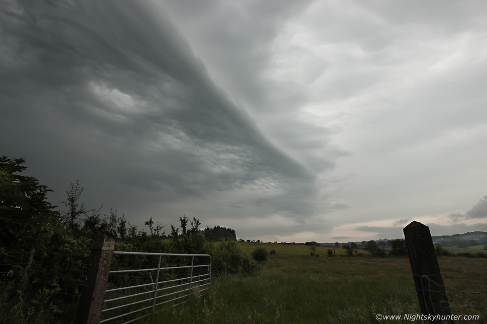 |
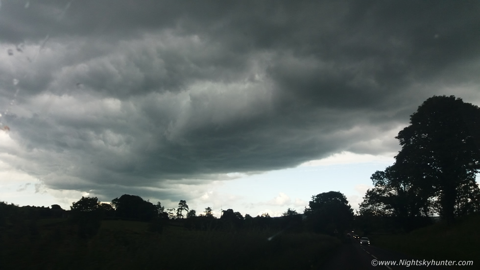
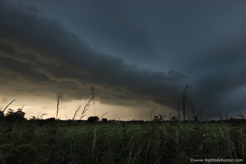
Against my better judgment I chased out the road, I raced N to get ahead of the cells and pulled over on high ground above Swatragh. I was bitterly disappointed, it was exactly has I had expected, a vast area of grey pea soup, no structure at all and no visible lightning, I felt like a fool standing out with the camera, this was a joke so I went back to the house. Despite the fact these storms were not camera friendly these still made an impact, especially further E, power was knocked out and there were reports of hail larger than marbles and even a dramatic account of hail roar from Co. Down, a phenomena more typical of the great plains. The sky this morning was filled with elevated asperatus undulatus then by midday the elevated storms cleared away to the NE, I could make out their towers then the warm sun broke out which was exactly what I needed for round two that evening, it was time for one final look at the charts.
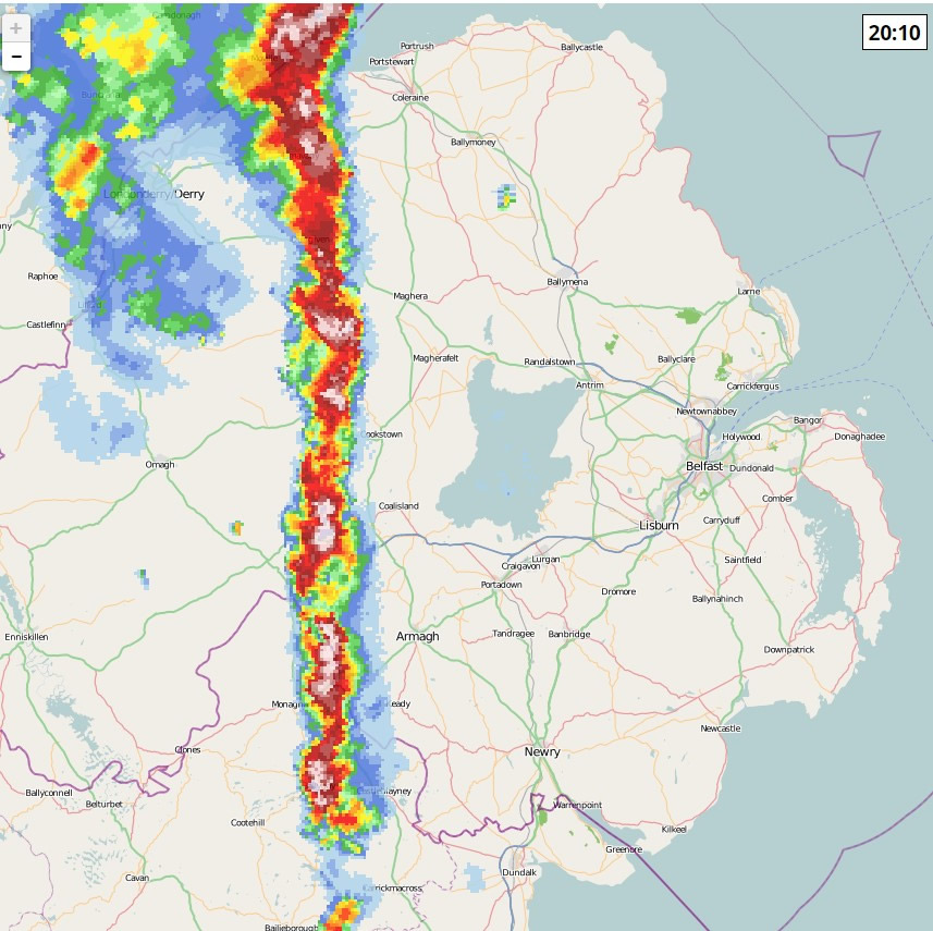
While everyone was focused on the storms to the E I was already planning to head W, to me there was greater potential for photogenic storms of the kind I was interested. In the wake of the plume GFS was showing 500 j/kg of CAPE moving into the W from 18.00 onward. There was cool air aloft, good heating with 22-23C temps, decent moisture, and what got my attention most of all was that the convective maps were showing this area of instability being over lapped with 80 knots of deep layer shear which was exceptional. 40 knots of DLS can produce supercell thunderstorms yet this afternoon in the W we would have twice this value. Furthermore the lightning wizard charts were also showing supercell and tornado parameters in this very same area. However the big question was would there be any precip or would this be yet again another 2019 cap bust? I spent hours studying all the intel I could find, the GFS was showing precip and the AROME did too, the latter in particular was showing very strong cells in an area from Fermanagh to Tyrone and over the Sperrins and near the Foyle area which really had my attention. So two models showed storm potential however when I checked the Met Office they gave it dry and sunny all evening, this I found very odd indeed. On a hunch I checked BBC NI weather on twitter and the television forecast, Barra Best gave a bone dry evening with not a drop of rain anywhere in the country. Now I was getting concerned, was this already a cap bust? did their models show something mine did not?, one thing about storm forecasting in this country is that you can never get a straight answer.
I double checked all the charts again then located a sounding which backed up all the models, this skew-T showed only weak CIN and a healthy temperature-dew point line and supported the CAPE values on GFS. It seemed that every source was screaming storm potential yet no one else was going for it. I'm fairly sure the 500 CAPE in the W was in the shadow of the 2000-4000 CAPE in the E, sometimes people can get too carried away by high figures, however the lower CAPE in the W would be associated with surface based storms which meant photogenic potential and mean clouds, furthermore the strong shear meant that updraughts would be tilted over, organized, of longevity and with the potential for tornadoes and even supercellular type structures, for me the case was closed, there was sufficient evidence the W midlands could produce this evening, I decided to trust my instincts.
During the early afternoon I was in conversation with Paul Martin, we looked over the charts and decided the potential was good and that we would both be chasing. However we considered it a better policy to wait for developments on radar first before making a move. I had the radar on my lap top running all the time so I could check it while doing other things, I needed to move position soon because if things kicked off later I would need to be as close to the W as possible for a last minute road trip. At 15.00 I drove from Maghera to Cookstown, it was a gorgeous warm sunny day and I suspected this heat would initiate convection, even more so further W where temperatures where hotter again, I began to get a good feeling. In Cookstown I kept refreshing radar, absolutely nothing on view, dry as a bone, maybe the television forecast had been correct. I decided to take a break from it for a while and watched a documentary on Netflix about Bob Lazar and Area 51, when it was over I grabbed a brew and refreshed radar. There was a compact red cell over Galway, it was at this moment that I knew this day was going to produce. I pm'd Paul and he had seen it too and was feeling the same way. As we watched two new cells formed N of Galway, by the next update these two had red cores and were already showing signs of being sheared, they were advancing N rapidly on the Sly flow and we knew it was game time. If they kept to their current trek they would arrive in Co. Fermanagh within two hours. I grabbed the gear, a flask of water, put on my lucky base ball cap and hit the road. Roisin was due back within the hour so I text her to say I was away chasing and would be back later.
I made great progress out the Cookstown-Omagh road despite initially getting stuck behind tractors and within 40 minutes I had arrived in Omagh just as Paul Martin arrived. Paul suggested we leave my van and continue in his jeep which was a great idea due to the extra space for gear, Paul's dog Oscar was in the back seat, he would be chasing too. Radar was now looking good, those earlier cells had now merged into a larger area and were getting closer so we wasted no time and shot W from Tyrone into Fermanagh, we didn't want to get too far W however or we would end up under the cores in rain so we decided to stay on the E side of the cells so we could always keep a visual.
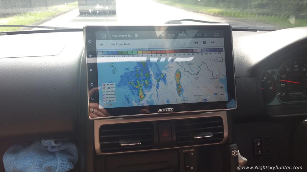 |
Paul had a fantastic set-up inside the jeep with a large tablet mounted on the dash which could be adjusted to any height. This tablet relayed information from his phone so we could get internet on the larger screen. We had Netweather radar on view the entire time, I was blown away by this idea, the ability to see up to date radar and compare it with the real sky while overlapping a road map was invaluable and which took our chase to the next level. Look down to see radar, look up to see the cell in real life, pretty awesome.
We pulled over at the service station in Kesh which turned out to be a perfect intercept location. We bought drinks and snacks and sat outside on a picnic table eating in the muggy warm air as dramatic storm clouds built close beside us, it's not often we had such luxury watching storms develop. A precip core was getting close while on either side two high based updraught bases were forming and getting our attention fast, both bases were dark and solid and developing a nice textured profile, they seemed to be rapidly growing, the closer base became so impressive we decided to give chase.
 |
After a snail-like start it suddenly seemed like a switch had been flipped and everything became dynamic and fast moving. We followed this dramatic new base through Kesh when suddenly the precip behind kept catching up on us hiding our view of the sky so we had to drive at a fast pace to stay ahead of the rain to even have a chance of seeing structure, it was from here on that this chase became intense and exciting with non stop action. We had our target in sight, we just needed to keep it within visual range, the plan was simple, chase this base and stay ahead of the rain. The base itself was a dramatic sight with sculptured structure and obscurations under the base, it was well sheared away from the precip on the right with striking updraught/downdraught separation, well organized, and even had that look as if it could produce a funnel. Because of our race with the core we had no time to pull over to get DSLR images so these were phone snaps.
 |
It was shocking how much this had developed on radar so quickly with numerous white cores, we where on the right side of these close to the leading precip moving E rapidly approaching Omagh.
 |
Outside Omagh the updraught base looked stunning with a well rounded shape indicative of rotation within the updraught, we were going mad looking a place to pull over to get DSLR structure shots but the road side lay out and rain spitting on the windows didn't allow us this luxury yet, this was already the best storm structure we had seen this season, we needed to get further W into drier air and get a break from the rain which always seemed be no further than a few inches behind us. Once we entered Omagh town our progress was slowed by traffic, when we emerged out of the congested area into the E side where the speed limit was 50mph we got stuck behind slow moving traffic, typical. The rain was now pounding us, leaves were getting stripped from the trees and ahead of us was a jeep pulling a small boat at 30 mph, to say we were frustrated was an under statement, minutes counted on this chase and this eejit was costing us big time, we were angry yet laughing at the same time, I christened him Captain Birdseye, we hoped his sailing was better than his driving. Paul saw an opening in the traffic and over took Captain Birdseye and at last we were free and moving fast once more.
 |
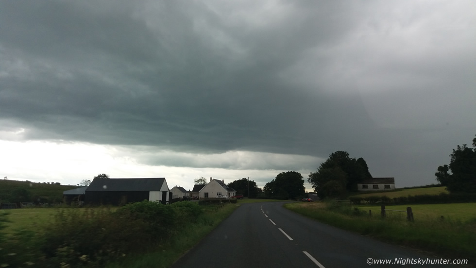
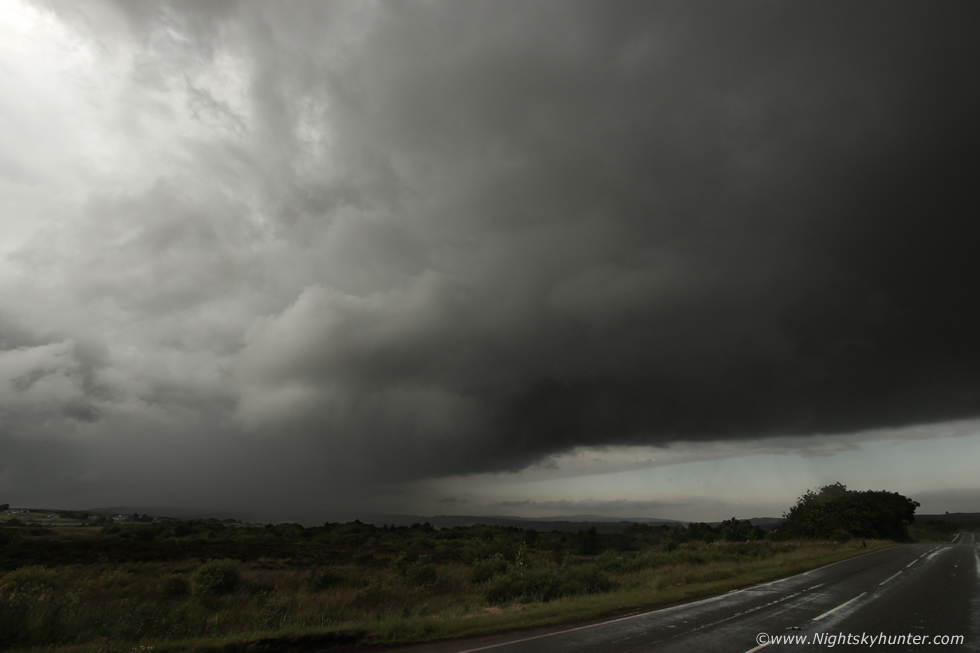
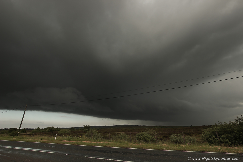
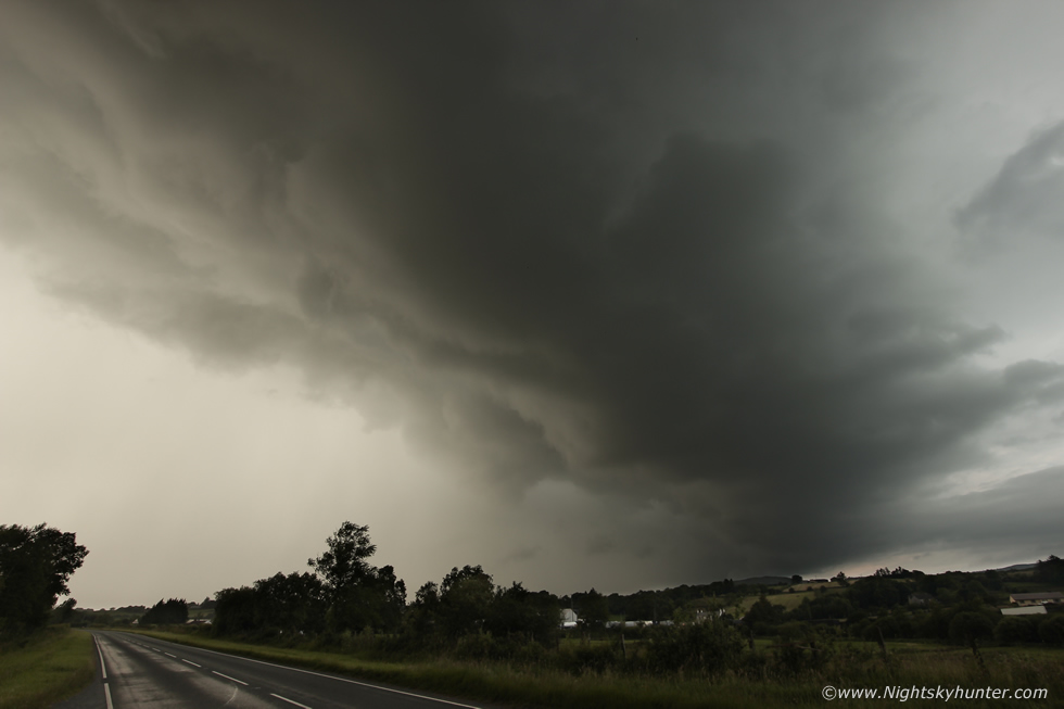
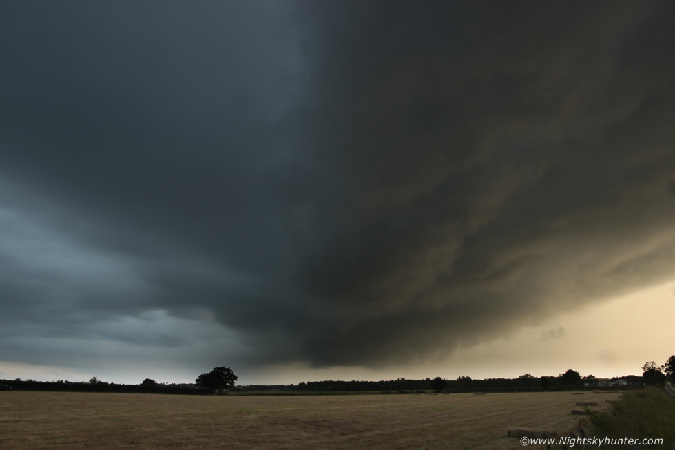
Paul suggested we drive to high ground for a better view so we took a back road and began to ascend a mountain, we had beat the precip and were once again getting a view of the structure, we just needed to reach the summit and get imagery. Suddenly a tractor pulled out in front of us and we were stuck behind him going slow up the mountain, we couldn't believe it, there were a few choice words yelled which I won't repeat here but with good fortune the tractor suddenly pulled over and let us past, perhaps he heard us screaming. We made it to the top with only minutes to spare as the cell would soon be over us once more. We jumped a gate into this nice field and got our first DSLR images of the day. I set up the tripod and began a time lapse, the set-up today wasn't well suited to time lapse photography due to the fast motion of storms but I gave it a go anyway. As the shutter clicked away we observed the growing storm, the warmth quickly transitioned to cooler air as we felt the outflow approach, Paul shot a cool panorama of the entire system using his phone. Radar showed that this was now forming into an intense line of cells, the visual view told us the same thing, the outflow was forming a gust front feature along the leading edge as the line moved from R to L, the blocky lower cloud was forming the beginning of a shelf cloud while the mid level cloud was projected far downrange by the stronger winds aloft. The rain drops hit us again and we ran back to the jeep, the line was moving N but also E thanks to a E-W moving trough so we needed to get E of it once more.
 |
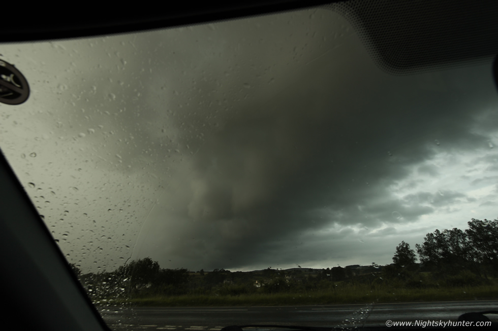
We drove frantically through heavy rainfall then punched through the core into dry air with better visibility, we pulled over in a layby on the Cookstown-Omagh road for another look. I ran across to this side of the road to get the gust front over the main road, I was using my trusty Samyang 10mm wide angle. It wasn't long before we noticed rotation rite over the road, that dark lowering was rotating in a very obvious fashion, Paul seen it too but just when things were getting interesting the rain arrived again and we lost view. Suddenly a jeep towing a boat drove past us, the driver beeped his horn, it was Captain Birdseye passing by. We where soaked in our t-shirts and ran back to the shelter of the jeep once more.
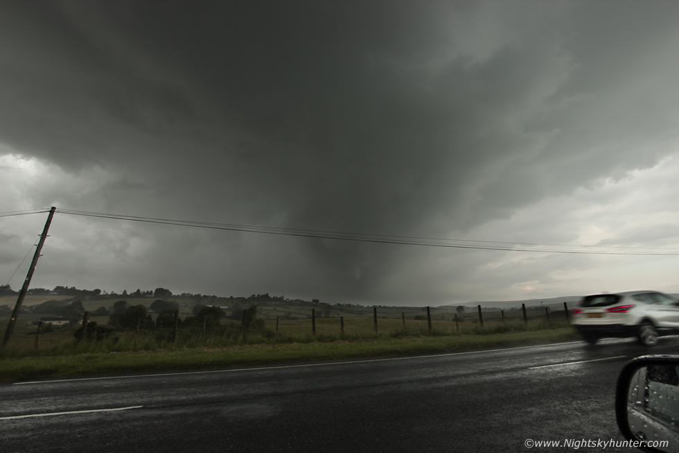 |
We had followed this line from Kesh to Omagh and were considering calling it a day, surely it was going to fizzle out soon. Not in the slightest! the radar showed it intensifying even more, we couldn't believe it, this storm just wanted to keep going, we laughed with joy, this chase was not over yet by a long shot and furthermore the southern end of the line was producing c-g lightning. I glanced out the passenger window through the falling rain and suddenly spotted a funnel, I shouted ''Paul, holy sh**t funnel!'', we couldn't believe it at first, but sure enough there was a funnel. A white tube under that same rotating area we had spotted minutes earlier, it became lost behind rain, we had no time to get images, then suddenly it re-appeared again, it looked like the funnel was carving itself clear from the sheets of precip, we ran outside into the torrential rainfall, I only had the 10mm on which makes it look small and far away, yet it was just under the base in a field on the other side of the road, but at least we had got it on camera.
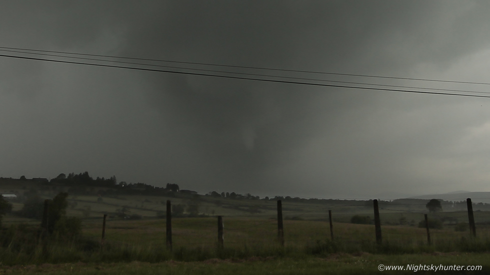 |
This is a deep crop, funnel clearly visible and even seemed to be wrapping cloud around with it, the camera was drenched and Paul and I were soaked clean through. Then the precip hid the funnel again like a curtain been drawn from left to right.
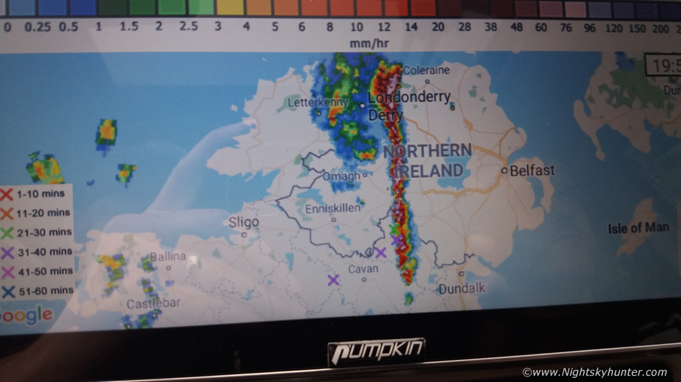 |
Radar at this time was madness, a huge squall line was moving SW to NE across much of N. ireland, even extending well below the border and was producing lightning. We continued to chase it E along the Cookstown-Omagh road closer to Cookstown, we encountered the worst rainfall we had seen all year, it was almost blinding to drive through, the road was saturated and rain drops battered the windscreen, we could barely hear ourselves talk, we continued driving through the core and began to make some head way, we had now extended the chase, there was no turning back, at this moment in time this was the convective event of the summer.
 |
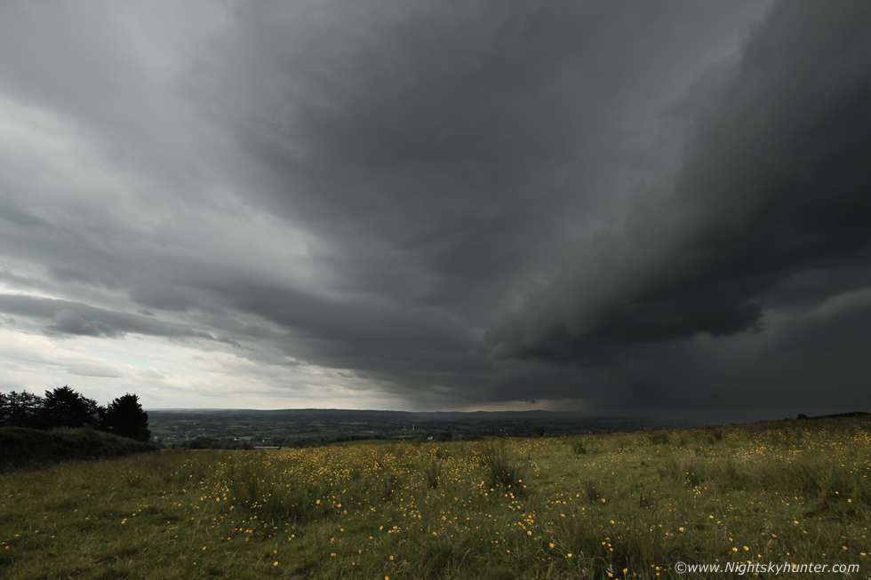
As we approached the vicinity of the Seven Sisters lakes we got treated to spectacular skies. We pulled over and jumped out for images, the air was muggy, warm and close yet very humid. We where looking E along the leading edge of the line, the clouds were huge, solid and black, the meanest skies we have seen for a long time, this is all at 10mm, this extended far out of frame to the right. The precip core on the left was a massive white area on radar at the top of the scale, but it was the black base to the centre which was putting on a show for us. Here the clouds were rotating like mad, continuous deep rapid rotation which kept spinning and spinning, it never eased, what made it even more dramatic was the clear sky ahead which made for great contrast and visibility, Paul and I had never seen such strong rotation like it in years.
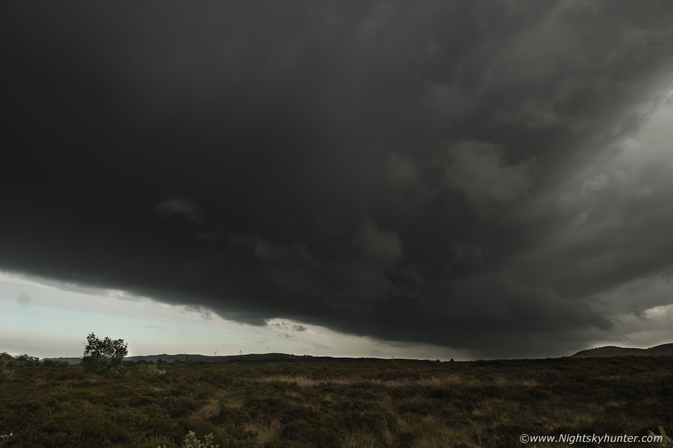 |
Panning the camera 90 degrees to the right, this was the other side of the line at 10mm wide angle, the clouds were even blacker than they look here. That long black solid line marked the S leading edge of the squall line, it was feeding left to right and merging into the previous image where the rotation was ongoing.
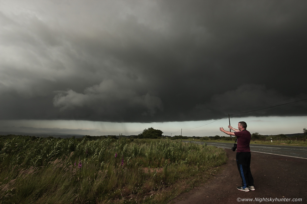 |
I ran back to the other side of the road to join Paul, the area left of the bush was spinning like mad, the rotation was even making those rain bands spin around the centre of the vortex which looked mind blowing against the distant clear sky, it looked for all the world like a supercell base in the USA rotating. Paul can be seen with arms outstretched explaining the rotation. We were both on a high at this point, we honestly expected another funnel or even a tornado to drop in these perfect viewing conditions, we had the boot open and ready just incase we needed to change lenses, but seeing this mean rotation in itself was an absolute treat.
 |
Turning to my right once more, this huge storm was like a living entity with dynamic motion while being shaped and sculptured by 80 knots of shear within the first 0m to 6km of the atmosphere.
 |
Still rotating like mad, it was rotating for so long we had the rare luxury of being able to look around at other areas of sky, check images, wipe lenses and check radar and look back and it was still rotating. A torrent of rain arrived again soaking us instantly, my lucky base ball cap was that wet it didn't feel solid any more. We drove on through torrential rainfall once more, so much for the bone dry forecast from the Met Office, we figured a good shelf cloud could be forming on the leading edge so we kept chasing, we moved E closer to Cookstown, it looked like we might not get ahead in time but we sure as heck tried, and succeeded.
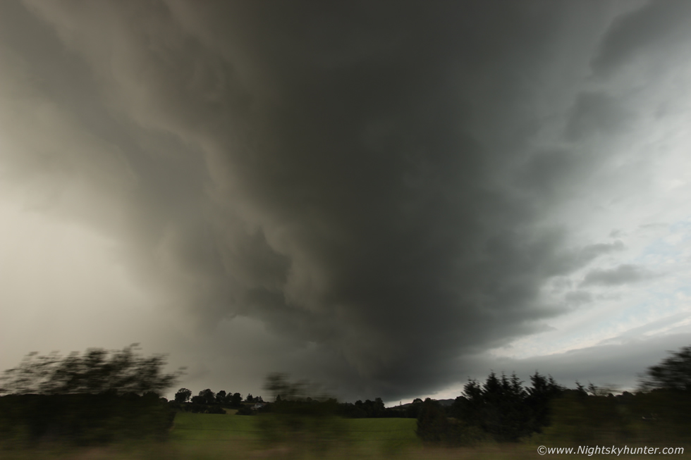 |
Holding the DSLR out the window shooting as we drove fast towards Cookstown, still raining hard, but just getting ahead and getting rewarded with big structure as a massive gust front swept low over the Co. Tyrone countryside. The image isn't out of focus, that's just motion blur from the trees racing past.
 |
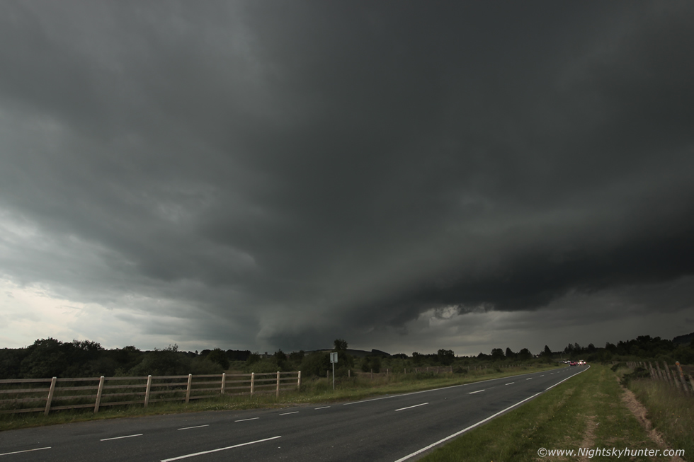
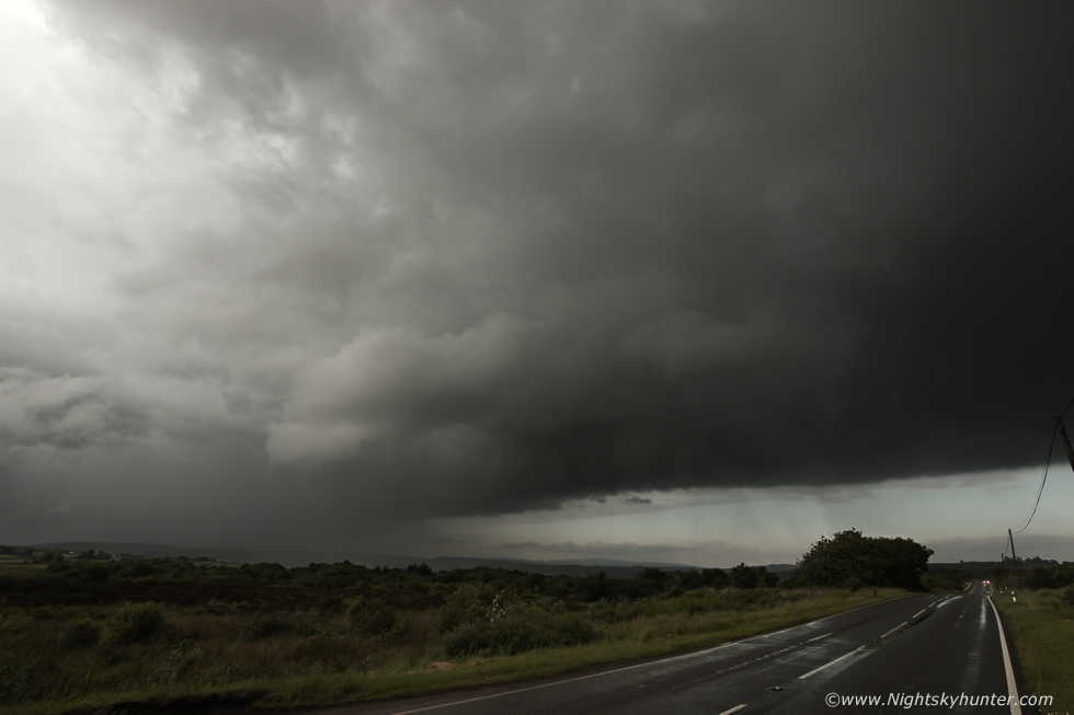
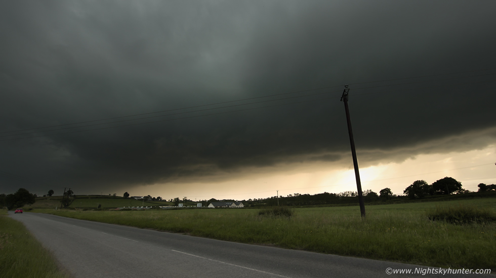
Another quick stop for images, gust front barrelling along the Omagh road, look at the size of that thing even at 10mm, I reckon we probably had three minutes before the rain was on us again.
 |
Back inside as the core hammered us, a quick capture through the windscreen before we drove off towards Cookstown. This would be our last move of the day, if we could get ahead one more time we might just get a few more dramatic shots, and perhaps by then the structure would be even more impressive, the sun was getting lower and the light was getting more atmospheric and this squall line was getting stronger all the time.
 |
We pulled over at a road side S of Cookstown, Paul reversed into a grass bank, the 4x4 came in handy. This was the view to the S, huge storm approaching, convective line with textured base all back-lit by the lowering sun. If this couldn't get any better we heard several angry rumbles of thunder, I set up the tripod and shot a short time lapse. Standing within the long grass with the farm in the foreground and this storm approaching felt like another part of the world, more like Kansas than Tyrone.
 |
A nice memory on camera with storm gust front approaching with Paul's jeep in the grass, I love storm chasing and these epic road trips chasing the atmosphere, we were glad we trusted our instincts, did our own forecasting and hit the road. We hoped our chaser mate John Fagan was getting this from Dungannon - he was!
 |
Insane radar with squall line the entire length of the country, the large white core W of Coalisland was producing lightning and moving N and E and was heading our way, we got ready for another intercept.
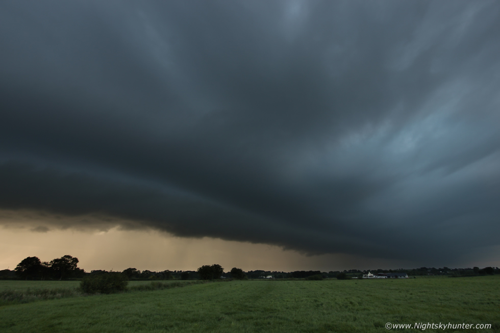 |
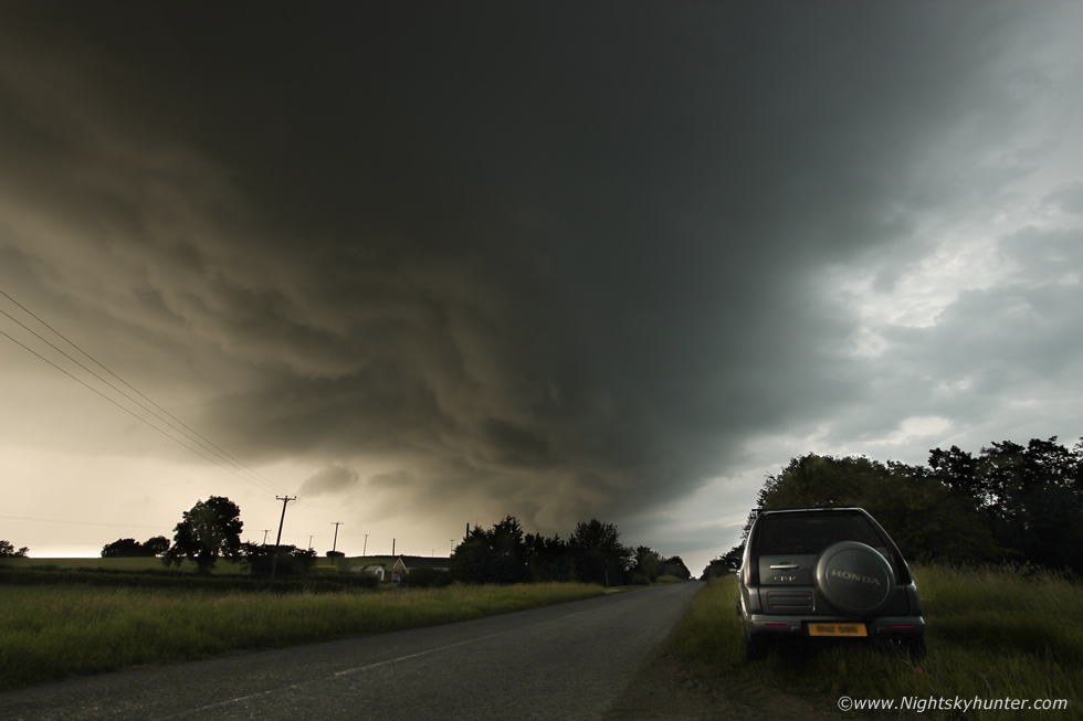
We drove through Cookstown under an intense white core, the rainfall was that bad that the man hole covers had become dislodged, we continued E out the old Coagh road and for the last time this day we punched the core and emerged into a lovely landscape of dry fields and mild air with great visibility. A big shelf cloud came into view just as we had hoped for, but trying to find a location free of obstructions was challenging, or even a place to pull over on these tight back roads full stop. Paul said to shout if we entered an open flat area, I scanned the countryside as power lines, poles, trees and tall hedges rushed past with not a break in sight, we hoped for a field with round bales of hay which would have been perfect, however anywhere open would do the job, we took a turn for Ballyronan and suddenly a clear part of the countryside revealed itself, we pulled over and bailed out for our final images of the day. This scene alone made the entire chase, in fact, it has made the entire season. A beautiful large shelf cloud dominated the sky over the scenic countryside near the west shore of Lough Neagh. The shelf had a photogenic laminar profile with a single tier running the entire length of the dark blue shelf, below the core was lit gold by the lower sun from behind, the scene was gorgeous, this is 10mm wide angle.
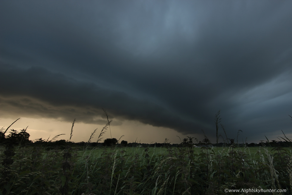 |
I began shooting another time-lapse, the shelf had slowed down in speed so it was more photo friendly however even with the tripod legs extended I couldn't get the camera high enough to clear the tall grass so I just shot the time lapse like this, it actually turned out really cool until rain drops began splashing my lens, I had to remove some of them from this image, but it was worth it, what a gorgeous storm scene and the type of structure we are always on the hunt for.
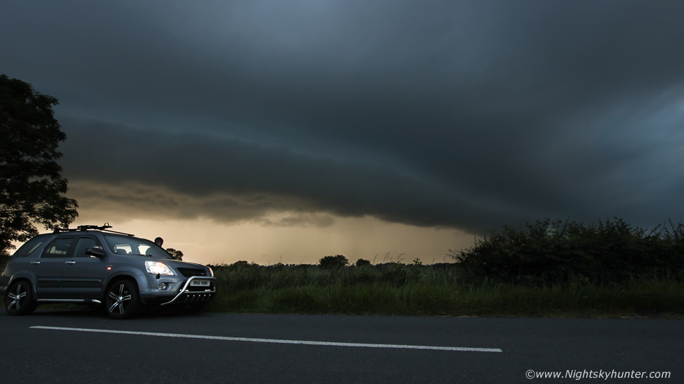 |
I was pleased with this one, thunderstorm shelf in the warm evening sunlight with Paul's jeep in the foreground. I have to give full credit to Paul for his quick reactions, solid driving and positioning, he was the one who kept us ahead of this squall line the entire time, getting rewarded with a funnel cloud, rotation, and now a beautiful shelf cloud all because of his sharp decision making and road choices. Paul never got a moment, it was fast paced action from Kesh to Lough Neagh with not even time to get a drink, or even get many images as he was driving, until now when it all paid off. Images don't even do this scene justice, the core was lit with greater intensity and colour than is portrayed here, it really was a visual treat. Watching scenes like this after an all-day chase with the smell of freshly cut fields, the chirping of birds, storm clouds, rumbles and all while wearing a t-shirt is for me the epitome of what a proper summer storm chase should be like.
 |
N side of the shelf about to pass over, this was an image taken from near the end of the time lapse captured from the great plains of Mid-Ulster. The squall line was still strong on radar as it moved E with red cores and periodic lightning, it was seen from the north coast, Maghera, Portglenone, Dungannon and many other locations.
 |
S side of the shelf as farmers were bringing in bales of hay. We called it a day, turned around, and headed back W again, as we did so the sky cleared revealing the back of the storm, we could see a flanking line of white towers and a beautiful vibrant rainbow. We went back to Omagh to collect my van, I thanked Paul then I began the drive back along the Cookstown-Omagh road where earlier we had seen a funnel and remarkable rotation, it was good to get action over some of my favourite storm chasing country, this really was like a proper chase from the good old days. Under clear skies moisture could be seen rising from the fields and road like steam after so much rainfall and to the E I could see the back end of the squall line now on the other side of Lough Neagh with the skyline filled with updraughts lit red by the setting sun. It was the perfect chase day and at last my hunger for storms was satisfied, that night I celebrated with a well earned glass of whiskey, or two.
Video footage detailing various aspects of the chase filmed with my phone and DSLR with 10mm lens, I hope it captures the excitement of the chase and our rush to stay ahead of this exciting storm. We chased from Co. fermanagh to Co. Tyrone, from Kesh to Lough Neagh, through towns and villages, across country roads and even a mountain, we had been on the road for 5 and 1/2 hours, this is what great memories are made of, thanks very much for reading.
Martin McKenna